About Geocoding
Geocoding a point assigns it precise longitude and latitude values in the system.
The system uses geocodes to calculate the distance and time it takes for a vehicle to travel from point to point along established routes. Geocoding also uses the Address Matcher functionality, which locates and verifies addresses by matching the address components of an object against available data. Address Matcher complements geocoding efforts by providing ranked address matches for each address search entry.
Geocoding can be done with or without the system map
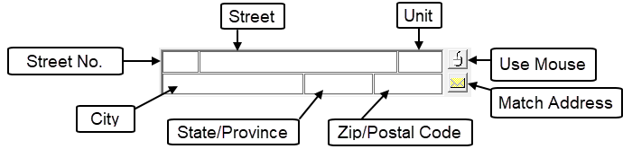
All address boxes in Trapeze4 share some characteristic features. Typically, the Street and Unit version of the address box is used. It displays information in the following order: street number, street name, unit, city, state/province, and zip/postal code.
You can perform geocoding in a few different ways:
- using an address (street number and street name)
- using an intersection (street and cross street)
- using the mouse and map
- based on street segments (used for stops)
The Address Matcher dialog box helps you geocode addresses. For example, addresses that require geocoding may be for a client, for an origin, or for a destination.
Sometimes, an address cannot be geocoded using any of the listed methods.