About the System Map
The system map provides a geographical representation of your service area.
(For FX users) If using Google Maps, please refer to the appropriate Google map documentation.
Basic Map Elements
- Vertical and horizontal scroll bars
- Located at the right (vertical) and bottom (horizontal) of the map, scroll bars allow you to adjust the map display so that you can see areas that are not currently in view.
- Current span
- Located below the map on the status bar in the right corner. Shows the distance
units in the system. For example, 10.30 miles East to West, 9.30 miles North to South.
If you cannot see any detail on the map, check to see if these values are too small
(the map may be zoomed in too close).
The current span shows a relational scale of the map. The values reflect the current zoom level of the map. Values become larger as you zoom out and see less detail. Values become smaller as you zoom in, and see more detail.
To turn off the current span indicator, click . Select the Map tab, and then click . Click No and click OK.
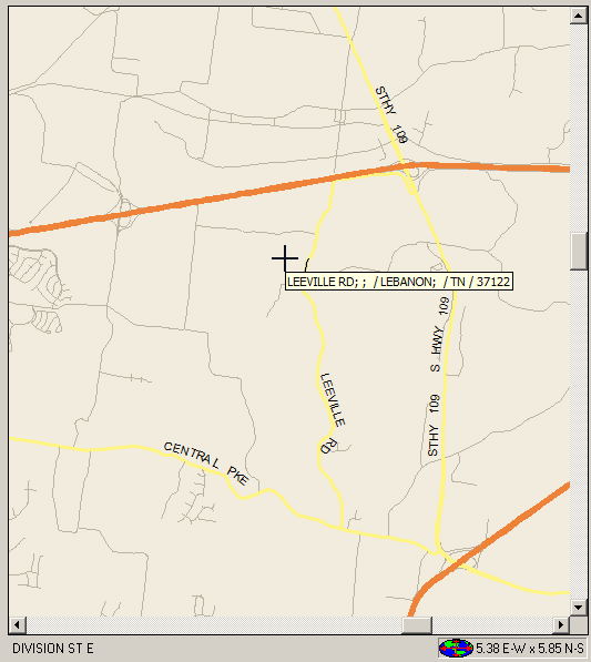
- Selected street or intersection
- Located below the map on the status bar in the left corner. When you click anywhere on the street network, this area displays the name of the nearest street or intersection at the point where you clicked the mouse.
- Information windows
- When you click a location on the map and hold the mouse button down, an information
window appears that shows information that includes any aliases for that location. For
example, a major road may be known as a street name at the local level, and a highway
name at the global level.
The information window shows the following information:
- Name
- Global alias
- Local alias
- City name
- MCD (minor civil division)
- State
- ZIP code
It is formatted as: Name;global alias;local alias/city;MCD/State/ZIP code
If there is no data between semicolons (;), it means that the corresponding data element is empty. For example, there may be no alias associated with the selected segment.