Adding Polygon Areas

Adding a polygon area allows a free-hand polygon to be drawn on the map to identify a prioritized area.

Before you begin

Open the Manage Incidents screen.

Procedure

  1. On the Priority tab's pane title bar, click the Polygon Area button.
    A Polygon Area section is added to the tab.
    A polygon area section with fields for Name and Priority.
  2. Plot the polygon on the map:
    1. On the map toolbar, click the Plot button.
    2. Click the Plot button again to select how the polygon will be drawn on the map:
      Disable Snapping
      Turn off snapping of polygon lines and vertices to street segments.
      Snap to Segment Vertex Only
      Only vertices can be drawn when street segments are clicked.
      Snap to Segment
      Lines and vertices can be drawn only when street segments are clicked.
      Street Routing
      Lines and vertices can be drawn only along street segments.
    3. Draw the polygon on the map by clicking the map to identify the vertices of the polygon.
    4. Double-click the first vertex to enclose the polygon area.
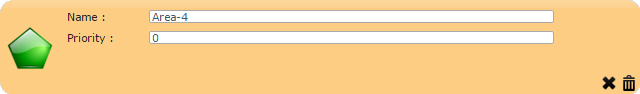
  3. Provide the following information about the incident:
    Name
    Type a name for the affected area.
    Priority
    Type the priority number of the area.

    The higher the number, the higher the priority.

  4. If you make a mistake while defining the polygon on the map, you can undo the last change made by clicking the Undo Latest Change button in the lower-right corner:
    An X.
  5. Click the Save button:
    Diskette.
  6. When prompted to save the record, click OK.