Adding Point and Radius Areas
Mapping an incident-affected area using a point and radius highlights the area on the map in a circle.
About this task
The default value can be changed by setting the following context property:
Procedure
- Click the Menu tab.
- Click Manage Incidents.
-
Search for or create an Incident record.
The Incident step is selected.
- In the Incident step, click the Affected tab.
-
On the Affected tab's pane title bar, click the Add
Point and Radius Area button:

A Point and Radius section is added to the tab.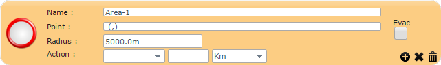
-
Plot the center of the affected area on the map:
-
On the map toolbar, click the Plot Circular Area
button:
- Press Ctrl on the keyboard and click the center of the affected area on the map.
-
On the map toolbar, click the Plot Circular Area
button:
-
Provide the following information about the incident:
- Name
- Type a name for the affected area.
- Point
- Automatically populated when the record is saved.
- Radius
- Adjust the side of the circle by typing the length of the radius.
- Evac
- Select whether the area needs to be evacuated.
- Action
- (Optional) Define the street speed of the area.
-
If you make a mistake while defining the area on the map, you can undo the last change
made by clicking the Undo Latest Change button in the lower-right
corner:

-
Save the Incident record:
-
Click the Save button:

- When prompted to save the incident data, click OK.
The Point field is automatically populated with the latitude and longitude coordinates of the center of the circle.
-
Click the Save button:
-
To create an area to which a priority can be applied:
-
In the lower-right corner of the section, click the Create Priority
Area button:

-
Click the Save button:
-
In the lower-right corner of the section, click the Create Priority
Area button: