Adding Regional Areas
Incident-affected areas can be identified on the map by selecting a predefined polygon in the system.
Before you begin
About this task
To change the default dataset,
update the following context property:
- .
Procedure
-
On the Affected tab's pane title bar, click the Add
Regional Area button:

A Regional Area section is added to the tab.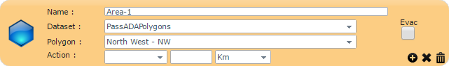
-
Provide the following information about the incident:
- Name
- Type a name for the affected area.
- Dataset
- Click a dataset in the list.
- Polygon
- Click a polygon in the list.
The polygon is shown on the map.
- Evac
- Select whether the area needs to be evacuated.
- Action
- (Optional) Define the street speed of the area.
-
If you make a mistake while defining the region, you can undo the last change made by
clicking the Undo Latest Change button in the lower-right
corner:

-
Save the Incident record:
-
Click the Save button:

- When prompted to save the record, click OK.
-
Click the Save button:
-
To create a regional area to which a priority can be applied:
-
In the lower-right corner of the section, click the Create Priority
Area button:

The name of the regional area is copied to the Priority tab.
-
In the lower-right corner of the section, click the Create Priority
Area button: